- ⬅ Back to Southern Interior Cams
 Southern Interior - Hwy 1 (Trans Canada Highway)
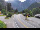
Yale - N
Hwy 1, at Victoria Street in Yale, looking northbound.
Yale - S
Hwy 1, at Victoria Street in Yale, looking southbound.
Alexandra Bridge - N
Hwy 1 at Alexandra Bridge, looking north.
Alexandra Bridge - S
Hwy 1 at Alexandra Bridge, looking south.
Hells Gate - N
Hwy 1 at Bradley Hill, about 3.5 km south of Hells Gate, looking north.
Hells Gate - S
Hwy 1 at Bradley Hill, about 3.5 km south of Hells Gate, looking south.
Boston Bar - N
Hwy 1 at Kahmoose Rd in Boothroyd, 12 km north of Boston Bar, looking north.
Boston Bar - S
Hwy 1 at Kahmoose Rd in Boothroyd, 12 km north of Boston Bar, looking south.
Gladwin - W
Hwy 1, about 6 km east of Lytton Airport, looking west.
Gladwin - E
Hwy 1, 6 km east of Lytton Airport, looking east.
Spences Bridge
Hwy 1, on the west side of the Thompson River at the north end of Spences Bridge, looking north.
Cache Creek
Hwy 1 at Collins Rd, looking east on Hwy 1/97.
Savona
Hwy 1 at Holloway Drive, near Savona, looking west.
Dufferin - W
Hwy 1 in Kamloops, east of Copperhead Drive, looking west.
Dufferin - E
Hwy 1 in Kamloops, east of Copperhead Drive, looking east.
Kamloops - W
Hwy 1 at Peterson Creek bridge in Kamloops, looking west.
Kamloops - E
Hwy 1 at Peterson Creek bridge in Kamloops, looking east.
Miners Bluff - W
Hwy 1, between Monte Creek and Pritchard, looking west.
Miners Bluff - E
Hwy 1, between Monte Creek and Pritchard, looking east.
Squilax - W
Hwy 1, east of Squilax Bridge, looking west.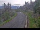
Squilax - E
Hwy 1, east of Squilax Bridge, looking east.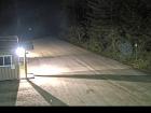
Adams Lake West Ferry Lineup
Adams Lake Ferry west shore landing, looking at ferry line up toward Rawson Road.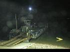
Adams Lake West Ferry Landing
Adams Lake Ferry west shore landing, looking at ferry landing on west side of lake.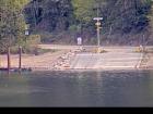
Adams Lake East Ferry Landing
Adams Lake Ferry east shore landing, looking at ferry landing on east side.
Sorrento - Blind Bay
Hwy 1, at Highland Drive east of Sorrento at the Blind Bay turn off, looking southeast.
Salmon Arm - N
Hwy 1 at 30th Street SW in Salmon Arm, looking north.
Salmon Arm - W
Hwy 1 at 30th Street SW in Salmon Arm, looking west.
Salmon Arm - E
Hwy 1 at 30th Street SW in Salmon Arm, looking east.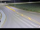
Salmon Arm - S
Hwy 1 at 30th Street SW in Salmon Arm, looking south.
Annis Pit - W
Hwy 1 at Annis Pit, 8 km southwest of Sicamous, looking west.
Annis Pit - E
Hwy 1 at Annis Pit, 8 km southwest of Sicamous, looking east.
Sicamous - W
Hwy 1, east of Sicamous at Cambie/Solsqua Roads, looking west.
Sicamous - E
Hwy 1, east of Sicamous at Cambie/Solsqua Roads, looking east.
Perry River - W
Hwy 1 near Perry River Bridge, about 30 km east of Sicamous, looking west.
Perry River - E
Hwy 1 near the Perry River Bridge, about 30 km east of Sicamous, looking east.
Eagle River - W
Hwy 1, about 33 km west of Revelstoke, looking west.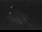
Eagle River - E
Hwy 1, about 33 km west of Revelstoke, looking east.
Griffin Lake - W
Hwy 1, by Griffin Lake, about 27 km west of Revelstoke, looking west.
Griffin Lake - E
Hwy 1, by Griffin Lake, about 27 km west of Revelstoke, looking east.
Three Valley Gap - W
Hwy 1, near Three Valley Gap, about 20 km west of Revelstoke, looking west.
Three Valley Gap - E
Hwy 1, near Three Valley Gap, about 20 km west of Revelstoke, looking east.
Clanwilliam Railway Overpass - W
Hwy 1, west of Revelstoke, looking west.
Clanwilliam Railway Overpass - E
Hwy 1, west of Revelstoke, looking east.
Boulder Hill - W
Hwy 1, about 7 km west of Revelstoke, looking west.
Boulder Hill - E
Hwy 1, about 7 km west of Revelstoke, looking east.
One-Mile Hill - W
Hwy 1, about 4 km west of Revelstoke, looking west.
One-Mile Hill - E
Hwy 1, about 4 km west of Revelstoke, looking east.
Hwy 1 at Hwy 23 - N
Hwy 1 at Hwy 23 in Revelstoke, looking north to Westside Road.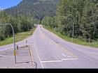
Hwy 1 at Hwy 23 - W
Hwy 1 at Hwy 23 in Revelstoke, looking west.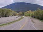
Hwy 1 at Hwy 23 - E
Hwy 1 at Hwy 23 in Revelstoke, looking east.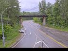
Hwy 1 at Hwy 23 - S
Hwy 1 at Hwy 23 in Revelstoke, looking south to Hwy 23.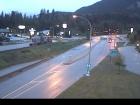
Revelstoke
Hwy 1 at east end of Columbia River Bridge in Revelstoke, looking eastbound.
Albert Canyon
Hwy 1, about 30 km east of Revelstoke, looking east.
Jack McDonald Snowshed
Hwy 1, about 46 km east of Revelstoke, looking east.
Rogers Pass
Hwy 1, Rogers Pass in Glacier National Park, 72 km east of Revelstoke, looking east.
Quartz Creek
Hwy 1, 40 km west of Golden, near the Quartz Creek bridge, looking east.
Donald Bridge - W
Hwy 1, about 28 km north of Golden at Donald Bridge, looking west.
Donald Bridge - E
Hwy 1, about 28 km north of Golden at Donald Bridge, looking east.
Blaeberry - NW
Hwy 1, near Blaeberry River Bridge, looking northwest.
Blaeberry - SE
Hwy 1, near Blaeberry River Bridge, looking southeast.
Golden northbound
Hwy 1, at Hwy 95 interchange, looking northbound along Hwy 1.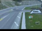
Golden eastbound
Hwy 1, at Hwy 95 interchange, looking eastbound along Hwy 1.
Golden southbound
Hwy 1, at Hwy 95 interchange, looking southbound along Hwy 95.
Kicking Horse Canyon
Hwy 1 (Kicking Horse Canyon) at 10 Mile Brake Check, looking east.
Field - SW
Hwy 1 at Field Access Road, about 16 km west of BC/Alberta border, looking southwest.
Field - NE
Hwy 1 at Field Access Road, about 16 km west of BC/Alberta border, looking northeast
Field - SE
Hwy 1 at Field Access Road, about 16 km west of BC/Alberta border, looking southeast.
Lake Louise - W
Hwy 1 west of Lake Louise Overpass in Alberta, looking west.
Lake Louise - E
Hwy 1 west of Lake Louise Overpass in Alberta, looking east.
Castle Mountain - W
Hwy 1, at Hwy 93 South junction, looking west.
Castle Mountain - E
Hwy 1, at Hwy 93 South junction, looking east.
Castle Mountain - S
Hwy 1, at Hwy 93 South junction, looking south.
Banff - W
Hwy 1, east of Sunshine ski hill overpass in Alberta, looking west.
Banff - E
Hwy 1, east of Sunshine ski hill overpass in Alberta, looking east.


